Asnebumskit.net
The effort to capture the historical record focusing in on the area making up the headwaters of the Kuttatuck. The modern name for this area is Greater Worcester in Central Massachusetts.
What We Know:
- There is general consensus that the area called Worcester County is the land of the Nipmuc People.
(It is bigger than this, but how much more so is not precisely defined.) - The Blackstone River was known as the Kuttatuck,
or “the great or main river” (think of Katahdin as “the great or main mountain” as a similar treatment.) - The northernmost reaches of the Kuttatuck watershed is the area we now call Worcester.
- There were three Nipmuc villages in the northernmost reaches of the Kuttatuck.
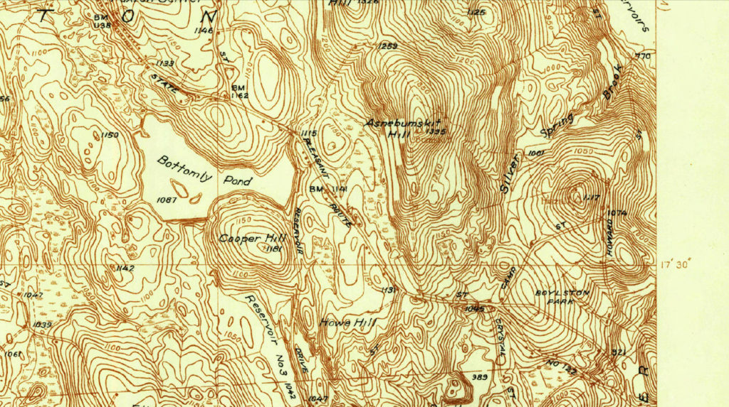
The Geographic Location of the Three Villages in the headwaters of the Kattatuck
Asnebumskit (Hasnebumskit): A very large hill in Paxton and Holden, and a pond in Paxton. The pond taking the name from the hill, probably derived from Hassun, a stone, and ompsk, a standing rock, with the locative suffix, at or near, signifying ‘the place where a large rock rises from stony ground.’ At a prominent place on the hill this is a striking feature. In some old deeds the name is spelled Hasnebumskeat and Hasnebumskeag. It is generally called by the inhabitants “Bumskit,” which is an acknowledged corruption. Also name give to brook in Holden.
Indian Place Names in Worcester County, Massachusetts, With Interpretation of Some of Them, Lincoln Newton Kinnicutt, 1905, Worcester, Massachusetts Page 10
Pakachoag (Packachoog, Boggachoag): A hill in the southeastern part of the City of Worcester. Lincoln, in his history of Worcester, gives twelve different spellings of this name. Gookin speaks of it in 1675 as the name of one of the Indian praying villages… we also have Pachaug (Pachau-auke), denoting a turning place, and at this point the Blackstone [ed. Kuttatuck]… river winds around the hill, and therefore might signify ‘the land where the river turns.’
Indian Place Names in Worcester County, Massachusetts, With Interpretation of Some of Them, Lincoln Newton Kinnicutt, 1905, Worcester, Massachusetts Page 33-34
Quinsigamond (Quansigemog, Quansigamaug, Quansigamug): Original name of Worcester. A small lake or large pond between Worcester and Shrewsbury; also the name of a village, taking its name from the lake, forming part of Worcester, from Qunnosuog-amaug, “the pickerel (or long nose) fishing place. Even at the present day this lake is noted for its pickerel fishing. Mr. William Lincoln, in his history of Worcester, gives nine different forms of this name, all taken from old deeds, etc. Worcester, in the edition of Hubbard’s Narrative, published in 1677, is described as “a village called Quonsigamog.”
Indian Place Names in Worcester County, Massachusetts, With Interpretation of Some of Them, Lincoln Newton Kinnicutt, 1905, Worcester, Massachusetts Page 43
The Kuttatuck
Kuttatuck (Kuttutuck, Tittutuck, Kittituck): One of the names of the Blackstone River. In Indian deed Feb. 10, 1681, of a tract of land which included what is now Oxford, to William Stoughton and Joseph Dudley; it is described as “Kuttutuck or Nipmug river.” Trumbull says: “The great river called Kuttatuck or Nipmug river,” so named in the first deed of the Nipmuck country by the Natick Indians in 1681. Khetetuck means ‘great’ or ‘principal’ river.” Kehti, ‘chief, principal, greatest;’ tuk, ‘a tidal or broad river.’
Indian Place Names in Worcester County, Massachusetts, With Interpretation of Some of Them, Lincoln Newton Kinnicutt, 1905, Worcester, Massachusetts Page 18
Colin M.J. Novick